


seaRoute is a high-performance maritime navigation, ECDIS like visualizer, and optimal sea route computation engine written in Go and Leaflet. Built on top of the Eurostat Marnet navigation mesh (42,800+ nodes, 118,400+ nautical edges), it calculates shortest, navigable sea passages between any two global ports or arbitrary marine coordinates. Layers include maritime boundaries, piracy risk zones, emissions control areas, and live weather conditions.
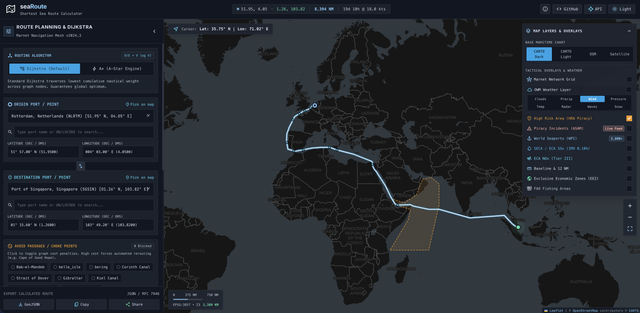

- Dual Routing Engines: Choose between standard Dijkstra (guaranteed lowest cumulative nautical weight) and heuristic A* (accelerated A-Star graph traversal).
- Strategic Choke-Point Avoidance: Restrict or permit transit through critical maritime passages, including Suez Canal, Panama Canal, Strait of Malacca, Kiel Canal, Strait of Gibraltar, Bab-el-Mandeb, Dover Strait, and Arctic routes (Northeast / Northwest Passages).
- Flexible Coordinate Input: Enter origin and destination by port name / UN/LOCODE (with instant autocomplete across 4,300+ ports), Decimal Degrees, Nautical Degrees-Minutes-Seconds (DMS), or click directly on the interactive map canvas.
- Tactical Design System: Crisp, high-contrast maritime interface optimized for low-glare bridge use, featuring Deep Sea Dark and Nautical Daylight modes.
- Transit Simulation & Vessel Telemetry: Interactive passage player with scrubber track, real-time simulated coordinates, elapsed days, and variable speed multipliers (1x, 5x, 20x).
- Dynamic Maritime Scale Bar: Dynamic nautical distance scale dock at the bottom-left calibrated in Nautical Miles (NM) and Kilometers (KM) with live Mercator zoom projection indicator.
- Manifest & Export: Full tabular waypoint manifest breakdown with individual leg bearings, nautical distances, and single-click GeoJSON or CSV export.
- Territorial Waters (12 NM Baseline): High-resolution territorial sea limits rendered via client vector tiles.
- Exclusive Economic Zones (EEZ & Boundaries): 200 NM sovereign economic boundaries and median lines.
- Piracy & Maritime Security (ASAM / HRA): High Risk Areas (HRA) polygon and live feed of verified piracy and armed robbery incidents with interactive tactical debrief cards.
- World Seaport Database (WPI): 3,600+ commercial harbors with harbor size, water depth, entrance width, and vessel draft constraints.
- IMO Emission Control Areas (ECA / SECA): SOx 0.10% and NOx Tier III compliance boundary visualization.
- FAO Fishing Zones: Major marine fishing areas for regulatory monitoring.
- Composable Weather Matrix: Overlay 8 meteorological layers powered by OpenWeatherMap 2.0: Wind Speed, Wave Height, Precipitation, Weather Radar, Sea/Air Temperature, Atmospheric Pressure, Cloud Coverage, and Snowfall.
- Calibrated Intensity Scale Dock: Positioned alongside the maritime distance scale dock, rendering continuous meteorological color gradients with calibrated physical unit ticks (KTS, M, MM/H, °C, hPa, %).
- Multi-Layer Selector: Clickable pill tabs automatically appear when multiple weather layers are enabled simultaneously, allowing swift legend toggling without interrupting map layers.
- Built-in native MCP Server (
/mcp) enabling AI agents and assistants (Antigravity, Claude, ChatGPT) to programmatically compute sea routes, inspect waypoints, query seaport coordinates, and analyze passage constraints.
The official container image is pre-built, self-contained, and hosted on the GitHub Container Registry. It bundles all pre-compressed, optimized datasets internally without requiring local volume mounts.
- Create a
docker-compose.yml:
services:
  searoute:
    image: ghcr.io/captv89/searoute:latest
    ports:
      - "8080:8080"
    env_file:
      - .env
restart: unless-stopped- Create a
.envfile for configuration:
PORT=8080
APP_ENV=production
# Optional: CARTO basemaps API key (falls back to OpenStreetMap if omitted)
CARTO_API_KEY=
# Optional: OpenWeatherMap API key for weather layers
OWM_API_KEY=
# Optional: Google Analytics measurement ID
GA_TRACKING_ID=- Launch the container:
docker compose up -dAccess the application in your browser at http://localhost:8080.
docker run -d \
  -p 8080:8080 \
  --name searoute \
  --env-file .env \
ghcr.io/captv89/searoute:latest- Go 1.22+
- GCC / CGO build toolchain (for SQLite embedded driver)
# Clone repository
git clone https://github.com/captv89/seaRoute.git
cd seaRoute

# Run tests
go test -v ./...

# Run the local server
go run .
Open http://localhost:8080 in your web browser.
| Variable | Description | Default |
|---|---|---|
PORT |
HTTP server listening port | 8080 |
APP_ENV |
Application environment (development / production) |
production |
OWM_API_KEY |
OpenWeatherMap API key for live radar and weather matrix | Optional |
CARTO_API_KEY |
CARTO vector basemap key (uses OpenStreetMap if omitted) | Optional |
GA_TRACKING_ID |
Google Analytics tracking identifier | Optional |
CSP_MODE |
report-only sends the Content-Security-Policy as Content-Security-Policy-Report-Only (fallback if the enforced policy blocks something) |
enforced |
TRUSTED_PROXIES |
Comma-separated proxy CIDRs allowed to set X-Forwarded-For (used for per-client rate limiting); none to ignore the header |
loopback + private ranges |
/waypoints, /ports and /mcp are rate limited to 60 requests per minute per client IP. Pages, static files and map layers are not.
The UI uses Tailwind CSS v3, prebuilt into web/static/tailwind.css (committed, so Go and Docker builds need no Node). After changing classes in the templates or web/static/script.js, rebuild it:
cd web/tailwind && npm ci && npm run build| Endpoint | Method | Description |
|---|---|---|
/ |
GET |
Main Tactical ECDIS dashboard web application |
/waypoints |
POST |
Calculate optimal sea route between ports or coordinates |
/ports |
GET |
Query commercial seaport database with UN/LOCODEs |
/passages |
GET |
List available choke-point passages and routing graph stats |
/network |
GET |
Stream raw Marnet navigation graph GeoJSON (gzip when accepted) |
/layers/:name |
GET |
Serve gzip-compressed tactical GIS overlays (baseline, eez, piracy, seaports, eca-sox, eca-nox, boundaries, fao) |
/emissions |
GET |
Stream IMO Emission Control Area (ECA) GeoJSON |
/mcp |
GET/POST |
Model Context Protocol endpoint for AI agent integration |
- Marnet Routing Mesh: Derived from the Eurostat searoute project.
- Maritime Boundaries & EEZ: Marine Regions (Flanders Marine Institute).
- Anti-Shipping Activity Messages (ASAM): National Geospatial-Intelligence Agency (NGA).
- World Port Index (WPI): National Geospatial-Intelligence Agency (NGA Pub 150).
- Emission Control Areas: International Maritime Organization (IMO MARPOL Annex VI).
This project is licensed under the MIT License — see the LICENSE file for details.